Not All Flood-Lines Are Equal (Part 2)
by Mark Bollaert | Aug 15, 2019 | Flooding
In the previous post (Part 1), the discussion centered around flood hydrology, which is one of two primary components in the simulation (or modelling) of flooding and resulting definition of flood-lines. The terms accuracy and detail as they relate to flood modelling were also defined and are likewise relevant to this post. As mentioned in Part 1, the purpose these two posts is to inform the reader as to the substantial variation in the approach and resulting accuracy and detail that is possible in the simulation of flooding (and by association flood-lines). This post lays out the options and cost-benefit with regards modelling of the distribution of river flow as it over-tops the banks of the river (aka hydraulic modelling), which commonly uses the flood hydrology design event estimate discussed in Part 1 as input.
Terrain Data
The flood (or hydraulic model) is the computer simulated part of the flood model which is built from terrain data that represents the river channel and floodplain. The better the representation of the terrain (or the surface over which flooding will occur), the better the resulting flood accuracy and detail, since the terrain data is the foundation of the hydraulic model. At this point, clarity is required on the difference between a Digital Surface Model (DSM) and Digital Terrain Model (DSM) both of which can interchangeably be called Digital Elevation Models (DSMs) as illustrated by the Figure below.
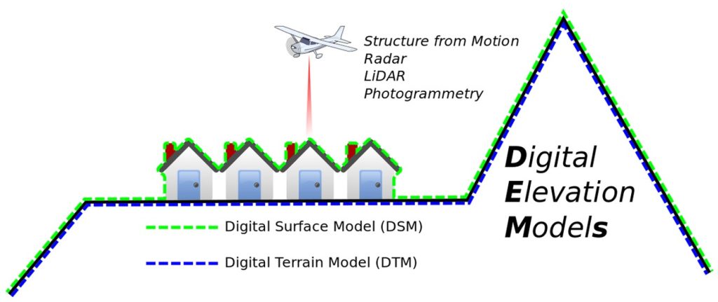
The DSM represents the surface of the earth inclusive of surface features such as buildings, vegetation and vehicles. For hydraulic (flood) modelling, the DSM is not suitable as it does not represent the surface or terrain over which water would flow. Instead a ‘bare earth’ DEM or DTM is required, which removes (or filters out) the undesirable surface features. In South Africa, as with rest of the world, we use two common types of terrain data for flood modelling purposes
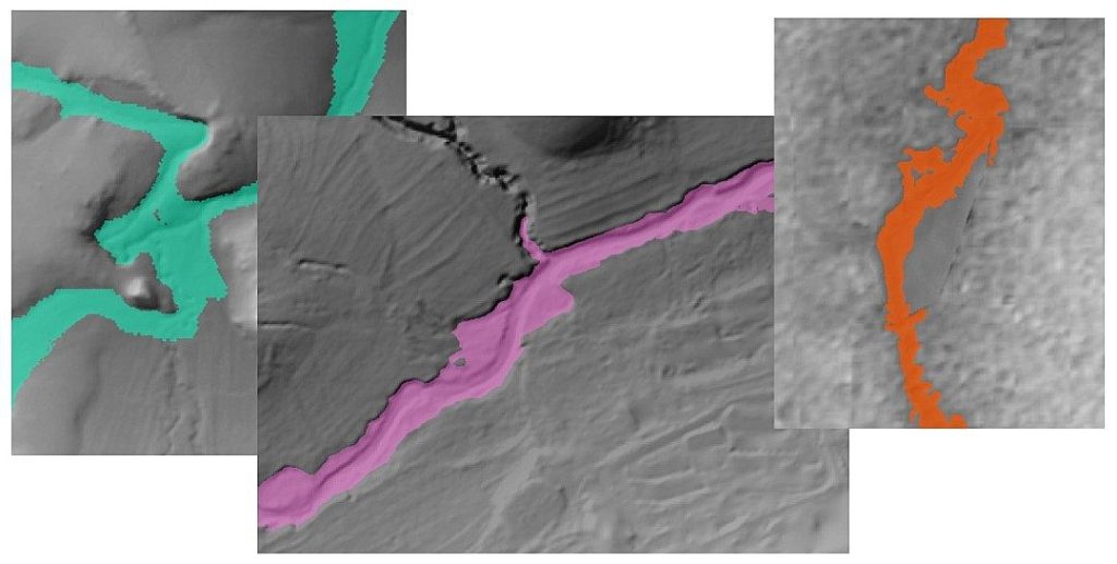
- Cross-sections or transects are historically the most common form of terrain data used in flood modelling, which enable a representation of the river channel and floodplain. Transects require a surveyor to take spot measurements along a transect line, perpendicular to the rivers flow. These transects pick up ground levels and are comparable to a DTM in this way. The limitation of transects is that while recorded elevation is accurate and representative of the terrain, detail between transects is non-existent which can result in important hydraulic feature being missed (e.g. a low point in a river embankment that would be the first point of river over-topping).
- Remotely sensed data from airplanes, drones and satellites provide a continuous representation of terrain to a varying degree of accuracy and detail and includes the following:
Photogrammetry
Traditionally, airplanes have provided orthophotos from which elevations of the surface can be derived using photogrammetry (which involves the use of aerial images to derive a DEM). Drones are a more recent introduction that through photogrammetry, enable DEMs to be derived in a more cost effective, detailed and accurate manner compared to that of traditional orthophotos. There are potential limitations in photogrammetry when it comes to flood modelling, however, due to their reliance on imagery and the initial elevations that represent a DSM inclusive of surface features such as grass, tress vegetation and buildings. Processing of DSMs derived from photogrammetry does enable development of a DTM, however, accuracy is affected in areas that are not bare earth, with poor accuracy in areas of dense vegetation.
LiDAR
Light Detection and Ranging (LiDAR) differs from photogrammetry in that it utilizes the scattering and measured reflection of millions of laser points that can penetrate through small gaps in thick vegetation removing one of the key disadvantages of drone photogrammetry while improving on both detail and accuracy at an increased cost. In this way, LiDAR can produce accurate and detailed DSMs and DTMs.
Satellite Data
Satellite data can enable a cost effective (free) option with regards to obtaining a DSM for a site, however, this comes at the expense of both detail and accuracy (which is poor), making this an unsuitable option for flood modelling in most instances. Modelled flood-lines may need to be defined as ‘indicative’ where terrain data is of poor quality, which limits the use of satellite data to scenarios where flooding does not make a significant difference to planning (i.e. where a tick-box approach is needed).
In general, the more detailed/accurate the elevation data used, the more constrained (i.e. narrow) the resultant flood-lines are likely to be. This has a positive influence where planning will be constrained by defined flood-lines.
Limitation of Remotely Sensed Terrain Data
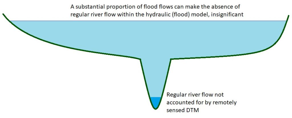
Remotely sensed sources of DTM data (photogrammetry, LiDAR and satellite) can be limited by their inability to penetrate water, as found in river and dams. This has the implication of limiting channel detail (for rivers), with the greater the depth and extent of water, the greater the negative influence on the integrity of the hydraulic (flood) model. This loss of integrity is due to the flow occurring beneath the water surface which the remotely sensed DTM does not capture (instead it captures the top of the water surface). When the remotely sensed DTM is used to model flooding, the water surface becomes representative of the river bed , which results in more conservative flooding (where more flooding is conservative) for flood models which only rely on remotely sensed DTM data.
Many rivers in South Africa are fortunately non-perennial with no flow at times, or either have minor ‘regular’ flow, which enables the sole use of a DTM to undertake flood modelling, given the small proportion of regular river flow to design flood flows. This is illustrated in the figure below where minor ‘regular’ river flow is proportionally insignificant to the flood flow. For rivers which have more substantial ‘regular’ flows, surveyed transects of the river channel only (i.e. not including the floodplain) allow for river conveyance to be better represented in a hydraulic model which utilises a DTM.
Cost-Benefit of Hydraulic (Flood) Model Approach
The available terrain data for a site (i.e. surveyed transects or remotely sensed DTM), often determines the approach to the hydraulic model which can be 1D, 2D or a combination of 1D and 2D:
- A 1D approach is usually necessary where available terrain data is in 1D (as is the case with transect lines which are one dimensional).
- A 2D approach is normally used where a DTM is available, since a DTM provides terrain data which covers an area (in two dimensions).
- A 1D/2D approach combines the river channel detail made possible by transects, with the spatial coverage of a DTM and is used where both transects and a DTM area available.
A site of interest requiring a definition of expected flooding (i.e. flood-lines) may already have terrain data available in the form of a drone survey or LiDAR. In this case, the available data will usually be used to develop the hydraulic (flood) model to limit cost to the client.
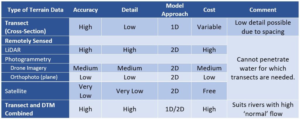
In instances where no terrain data is available, or where terrain data is limited, a cost-benefit analysis that considers the clients needs will be undertaken. This requires a discussion that accounts for available budget, the reason/intention for the flood-lines and possible alternative uses of the terrain data purchased for the project. A cost-benefit analysis is important since obtaining accurate and detailed terrain data for a site, can cost substantially more than the modelling of the flood-lines as undertaken by Hydrologic. The table below summarises the concepts outlined in this post and their influence on the flood model result, including cost. Actual cost for undertaking flood modelling will vary project to project.
Hydraulic Structures (e.g bridges, dams and weirs)
Hydraulic structures such as bridges, dams and weirs, can have a considerable influence on flooding. Bridges and associated culverts can cause significant ‘bottlenecking’ of flood waters which holds back flood waters, causing increased flooding upstream of the structure. Dams control flood waters using spillways with the spillway width and slope controlling the release of water. Lastly, weirs raise the level of streamflow upstream and can likewise increase upstream flooding.
Hydraulic structures may require surveying (e.g. of culvert size), depending on the cost-benefit considerations and the reason for the flood-lines, although minor structures (such as a small weir) can usually be excluded due to a limited influence on flooding.
Let Us Help You Find the Most Cost-Effective Option
To assist our clients, Hydrologic can arrange the necessary terrain data for the rivers where flood-lines are required, and survey for hydraulic structures (where necessary). To limit costs to the client, Hydrologic can also provide a recommendation as to suitable terrain data and a survey specification (for cross-sections or hydraulic structures where necessary), thereby allowing the client to avoid additional disbursement (middleman) fees.