There is often the need to consider the influence of a watercourse (e.g. a river) when starting a new development (or activity), even when the watercourse appears to be an insignificant part to the site. Evaluating the watercourse prior to defining the site layout can assist in both increasing the suitable space (frequently by more than 100m) as well as reducing the cost and difficulty of obtaining authorisation.
South Africa has legislation in place which guides the potential influence that a proposed development (or activity) has on a watercourse starting with the Section 21 water uses as defined in the National Water Act (Act No 36 of 1998) for which a water use licence (WUL) is required where applicable.
Two frequently applicable water uses are:
- 21(c) – impeding or diverting the flow of water in a watercourse; and
- 21(i) – altering the bed, banks, course or characteristics of a watercourse;
The reason for these two water uses being frequently applicable is due to the regular occurrence of watercourses in South Africa, since the National Water Act defines a watercourse as:
- a river or spring;
- a natural channel in which water flows regularly or intermittently; or
- a wetland, lake or dam into which, or from which, water flows.
A person reading the above definition may think that they wouldn’t need to consider a WUL with regards to Section 21(c) and (i) water uses by keeping their development/activity a little away from the edge of a river (for example). This would in most instances not be the correct interpretation as the area adjacent a watercourse which is intermittently flooded, also requires consideration as it is linked to the watercourse (with regards to the function and characteristics of a watercourse). But this leaves things open to interpretation since what ‘area’ or more specifically ‘regulated area’ are we talking about?
The Department of Water and Sanitation (DWS) have recognised both the frequent applicability of Section 21(c) and (i) water uses and the clarification of the watercourse area requiring regulation. They have accordingly published Notice 509 (of 2016) regarding the applicability of a general authorisation for Section 21(c) and (i) water uses (which if applicable would negate the need to apply for a WUL and to undertake the relevant supporting studies). Under this notice, the regulated area of a watercourse as it applies to the general authorisation (or GA) is as follows (with reference to section 21(c) or (i) water uses):
- The outer edge of the 1 in 100 year flood line and /or delineated riparian habitat, whichever is the greatest distance, measured from the middle of the watercourse of a river, spring, natural channel, lake or dam;
- In the absence of a determined 1 in 100 year flood line or riparian area the area within 100m from the edge of a watercourse where the edge of the watercourse is the first identifiable annual bank fill flood bench (subject to compliance to section 144 of the Act); or
- A 500 m radius from the delineated boundary (extent) of any wetland or pan.
In considering the first two points, the intent here is to define the area which is influenced by flooding (even if very rarely) by way of both the 1 in 100 year flood line and the riparian area of a watercourse. This then becomes the regulated area and any activity/development within it would potentially trigger Section 21 (c) and (i) water uses with areas outside being exempt.
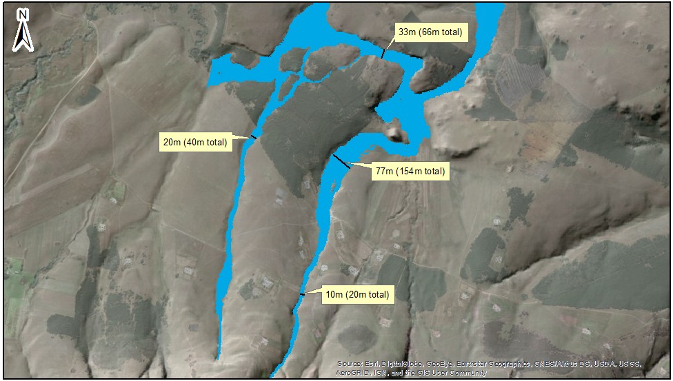
Furthermore, point (b) is of particular significance in its wording as it indicates that if either the 1 in 100 year flood line or riparian area are unavailable, then it would be necessary to use a 100m buffer, taken from the edge of a watercourse. This has substantial implications as illustrated in the figure at the top of this post which presents the 1 in 100 year flood line for a site (or the regulated area for the purposes of this post). Were point (b) to apply, the regulated area’s width would be at least 200m in total (2x 100m for each side of the river) and probably more when taking it from the edge of the watercourse. However, with the 1 in 100 year flood line defined, the regulated area’s width is reduced to between 20m and 154m (in total) for the four locations identified.
Where to from here?
At Hydrologic Consulting, we (as South African Council for Natural Scientific Professions members), can undertake the necessary study (including the required risk assessment) to firstly see whether an activity/development qualifies for a GA. Where a GA applies, we can compile the relevant documentation for submission to the DWS and where it doesn’t, we are able to provide the necessary expertise for obtaining a water use licence.